
TECH REVIEW - Handheld GPS
Garmin eTrex Handheld GPS
GARMIN eTREX HANDHELD GPS.
- OVERVIEW
- TESTING THE eTREX GPS ON FOOT
- TESTING THE eTREX GPS IN A CAR
- TESTING THE eTREX GPS IN A TRAIN
- TESTING THE eTREX GPS IN AN AIRCRAFT
- TESTING THE eTREX GPS IN A ROCKET
- CONNECTING AN eTREX GPS TO A PC
- CONNECTING AN eTREX GPS TO A PDA
- HACKING THE eTREX GPS
- Hacking the eTrex Software
- Hacking the eTrex Hardware
- REFERENCES
OVERVIEW
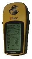
Figure 1: The Garmin eTrex GPS
One of the most well used of my electronic gadgets is definitely the eTrex GPS unit. This small, handheld GPS is invaluable for use on foot, in car, in train, in aircraft, or in rocket. The unit is very small, and easily slips into trouser or jacket pockets for carrying. The LCD display is clear and easily readable, although personally, I wish that waypoints (GPS marked location points that can be entered manually) could be given names or designations with more than 6 characters. The standard battery life of the eTrex GPS is supposedly around 22 hours, although in actual use, it is more like about half of this, and even less if the screen backlight is used much. The screen is 64 x 160 pixels, with 4 shades of grey. Not exactly huge, but sufficient.
Since the first eTrex was released, a whole family of eTrex GPS units has now been released by Garmin ranging up to units which include large internal storage capabilities for onboard moving maps (which can be downloaded from the internet), as well as built-in barometric altimeters and digital compasses.
The eTrex direction pointer screen indicates the direction to any waypoint that is stored in the eTrex GPS. The screen also displays the waypoint name, distance to the waypoint and time to reach the waypoing at the current speed. Additionally, a wealth of other useful data can be displayed on the pointer screen by toggling the side buttons. The following data can be displayed:
- Current Speed.
- Trip Distance. (Can be reset)
- Trip Time. (Can be reset)
- Sunset. (Local Time)
- Sunrise. (Local Time)
- Current Position. (Coordinates)
- Current Elevation.
- Bearing.
- Heading.
- Maximum Speed. (Can be reset)
- Average Speed. (Can be reset)
Testing the eTrex GPS on foot
I have used the eTrex GPS widely when out in the mountains - an environment where it excels. The X-Y positional accuracy is excellent, although the vertical acuuracy for altitude has often been 100-200 feet out. The eTrex tends to lose signal in trees quite easily, and also in the middle of a high rise city district. It has proved invaluable on rocket launch trips, when it is neccessary to recover a rocket. Whether in the mountains of Scotland or the middle of the Black Rock Desert in Nevada, U.S.A, the eTrex has been a real boon.
Testing the eTrex GPS in a car
When used in a car, the eTrex GPS has a range of uses. As well as considerably reducing the chance of getting lost, the fact that the speed, trip time, distance etc can be displayed, turns the eTrex into a small car computer. When connected to my Compaq iPaq PDA for a colour moving map display, the usefulness of the device is considerable. It is incredibly useful to know exactly where you are when out in the middle of nowhere. If a PDA (Windows CE or Palm OS) is connected, or even if the GPS is just being used standalone, it is generally a good idea to plug a Garmin car battery to GPS power cable into the eTrex GPS - this plugs into the car lighter socket and draws power from the car battery, thus extending the eTrex GPS's battery life. A good use for a GPS in a car (or on foot for that matter), is in the middle of a desert (not that there are many of those in the UK of course - none that I have found, in fact). Given that the surroundings in deserts are so featureless, and it is very hard to estimate scale and distance to any far-off objects, the GPS becomes invaluable.
Testing the eTrex GPS in a train
When the laptop batteries have run out, the supply of reading material has been finished, and there is little else to do on a long train journey, it is an opportunity for some impromptu tests of the eTrex GPS. It would seem that it is possible to get a GPS signal whilst in a train (apart from in a tunnel or a deep cutting), and not only that, but you can do useful things like find out if the blurb put out by the train companies in the UK is true, by setting the GPS to measure the speed, and if the trains really do go as fast as they are supposed to (the answer is, yes, they do on occasion, go over 125mph).
Testing the eTrex GPS in an aircraft
I have tested the eTrex GPS both in small, light aircraft (Piper Tomahawks), and large commercial airliners. In both types of aircraft, the GPS works well, measuring both location, speed and altitude very nicely, although in a commercial airliner, it seems to be neccesary to have a window seat, and have the GPS close to the window. The GPS allows the cruising speed and cruising altitude of the aircraft to be followed, as well as take-off and landing speeds - not neccesarily that useful in the great scheme of things, but an interesting diversion.
Testing the eTrex GPS in a rocket
"Nah, he's joking, isn't he ?". Well actually, no, my eTrex GPS has been launched on one of my rockets, and yes it did survive, and yes, I did get some useful data out of it. The idea behind launching the eTrex in a rocket was to see how it would stand up to the high acceleration of a rocket, would it lose lock on the high acceleration during launch and powered flight, and would it be possible to return a 3-dimensional plot of the flight from launch to landing.
The eTrex was fitted in a payload bay in the rocket (padded with bubble wrap), and the rocket motor ignited. The rocket blasted off , and according to plan, deployed a parachute at apogee (the highest altitude point of a rocket flight), and then gently descended to land. After connecting the eTrex to a laptop computer via the serial port, the data indicated that;
- (a) it worked
- (b) the GPS loses lock on the ascent under the high acceleration
- (c) the GPS re-acquires lock at apogee, so a nice 3-dimensional plot of the flight can be obtained,
- (d) the GPS does show the approximate altitude reached by the rocket, which can then be compared aganst the barometric altitude logged by the rocket's onboard altimeter.
Connecting an eTrex GPS to a PC
Garmin, the manufacturers of the eTrex GPS, sell a GPS to PC serial port lead, as well as a combined GPS to serial port and car lighter power lead. Either of these leads can be used to either download data from the eTrex GPS, upload software updates to the eTrex GPS or to use it as a moving map or for other real time data purposes. The lead is fitted with a plug on the eTrex connection end with 4 terminals. 3 terminals are used for PC communications; power, ground, Receive (Rx) / Data In and Transmit (Tx) / Data Out. the fourth terminal is used for power. The eTrex complies with the well used protocol for GPS units; the NMEA 0183 protocol. The NMEA 0183 protocol provides a standard output format for GPS data from a GPS unit.
One of the neat touches of the eTrex GPS, is the fact that new versions of the unit's firmware (the software within the unit), can be downloaded from the internet from the Garmin website, and then uploaded to the eTrex GPS via a PC, this prevents the unit from becoming rapidly obsolete - and is a feature that would be very useful on many other electronic devices.
CONNECTING AN eTREX GPS TO A PDA
An eTrex GPS can be connected to PDA's such as PalmPilots or Windows CE Pocket PC's via the same Garmin cables as those used for connection to a PC. There is one important difference however; A null modem needs to be fitted between the socket on the GPS cable and the PC serial port, since the internal wiring on a PDA serial port is different to that on a PC.
HACKING THE eTREX GPS
Hacking the eTrex Software
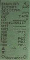
Figure 2: The Garmin eTrex
GPS hidden screen
One useful, but undocumented feature on the eTrex is an additional, hidden screen. The hidden screen is used for eTrex testing, and the hidden screen display indicates a very useful additional feature on the eTrex - a built in temperature sensor.
With the eTrex switched off, the hidden screen is accessed by holding down the UP button and PAGE button simultaneously, and then pressing the PWR button to switch the eTrex on. The hidden screen is then displayed.
The hidden screen also has additional useful system information, such as firmware version, battery voltage, time, frequency, signal to noise ratio (I presume), and screen display testing (accessed by pressing the PAGE button).
Hacking the eTrex Hardware
There is little scope for really creative re-use of the eTrex hardware without ending up physically breaking the unit. As a result, any changes are likely to be limited to the I/O connections on the eTrex. The data/power port on the eTrex enables the eTrex to communicate with any device that supports the RS-232 serial protocol (e.g. PCs, PDAs and in theory, embedded microcontrollers). The eTrex then communicates with whatever device it is attached to via one of several protocols that can be chosen via the eTrex system menu. The most common protocols used are the Garmin protocol, and the NMEA0183 protocol, and via these protocols, the eTrex can download its data (waypoints, routes, tracks etc) to third party software such as GPSU and OziExplorer.
The pinout for the eTrex when connecting it to a device with a serial port such as a PC or laptop is as follows:
| eTrex Outputs | RS-232 Serial port | |
|---|---|---|
| Power | not connected | |
| Data In | Tx | 3 |
| Data Out | Rx | 2 |
| Ground | GND | 5 |
PROS
- Small
- Rugged
- Waterproof
- Decent price
CONS
- The GPS receiver could do with being a bit more sensitive
CONCLUSIONS
If you want a rugged outdoor GPS receiver that is also cheap, and simple to use, the Garmin eTrex is highly recommended.
| Signal Quality: |

 4/5
4/5 |
| Battery Life: |
4/5 |
| External Connectivity: |
4/5 |
| Ergonomics: |
4/5 |
| Build Quality: |
4/5 |
| Screen Quality: |
3/5 |
| Overall: |
2.5/5 |
REFERENCE LINKS
- Garmin - The eTrex manufacturer
- OziExplorer - GPS software for Windows and Windows CE PCs.
- G7ToWin - GPS Software for Windows and DOS PCs.
- GPSU - GPS Utility Software for Windows
